
Terrain#
Terrain input is a bare-earth digital elevation model (DEM): not a visual 3D tile and not a
surface model that contains buildings. terrain="elevation" samples a DEM onto the local
grid, terrain="flat" keeps a planar ground at local z = 0, and terrain="none" removes
ground geometry entirely.
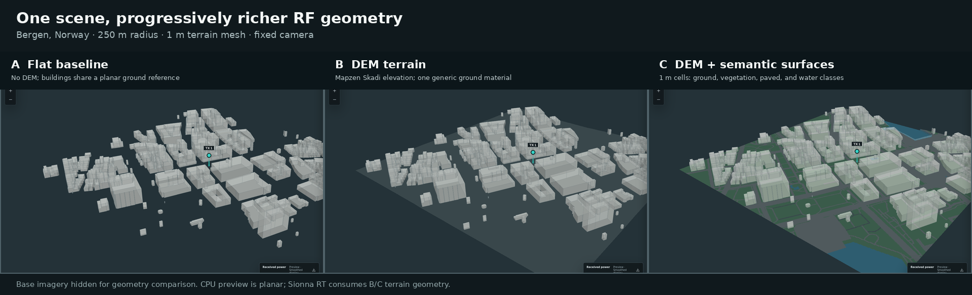
The same Bergen scene: flat ground (A), the elevation-following mesh with one ground material (B), and the same mesh split into ground, vegetation, paved and water surfaces (C).
Providers#
- United States
The USGS 3DEP Bare Earth DEM Dynamic service. OWRT queries the service catalog at the scene origin, chooses the highest-resolution source item, requests a bounded floating-point raster, and records the product title, reported resolution, vertical datum and metadata sample coordinates. A larger scene may cross product boundaries, so this point metadata is not presented as a uniform accuracy guarantee for the whole box.
- Elsewhere, or when a bounded 3DEP request has no complete result
Mapzen Terrain Tiles on AWS, using the analytical Skadi HGT product rather than display tiles. Gzip payloads are decoded as big-endian signed 16-bit values and bilinearly sampled in their one-degree grids. Every tile, the upstream imagery sources reported by Mapzen, the actual grid spacing, the interpolation and the EGM96 orthometric datum are recorded.
Both products can contain bathymetry. HGT voids and values outside -500 m to 9,000 m are rejected rather than filtered or inpainted. No denoising, vertical exaggeration or learned super-resolution is applied.
Three elevation arrays#
Each terrain-enabled scene stores three grids under terrain/:
File |
Content |
|---|---|
|
Provider elevations sampled onto the local grid, unchanged |
|
Ground elevations after the recorded modelling operations |
|
Model elevations minus the model elevation at ENU |
The only modelling operation is water levelling. Overture polygons explicitly classified as
ocean, bay, sea or strait are set to the datum’s 0 m level; other water components are set
to the median of their source vertices. Each levelled component is horizontal, its basis,
affected cells and vertices, original range and vertical datum are recorded, and no tidal
correction is applied. A building whose anchor falls in a water cell is placed relative to
this modelled surface rather than the submerged DEM. See Surfaces and materials for how the water
class is determined.
Three independent resolutions#
Resolution |
Controlled by |
Meaning |
|---|---|---|
Source DEM resolution |
the provider |
Reported and recorded; never improved by OWRT |
Terrain mesh spacing |
|
Deterministic resampling and triangle density |
Radio-map cell size |
the solver request |
Receiver grid or measurement surface spacing |
Requesting a 5 m mesh from a nominal 30 m source remains a resampled 30 m product. The terrain grid is limited to 250,000 cells; a request that exceeds it is rejected with the spacing to increase.
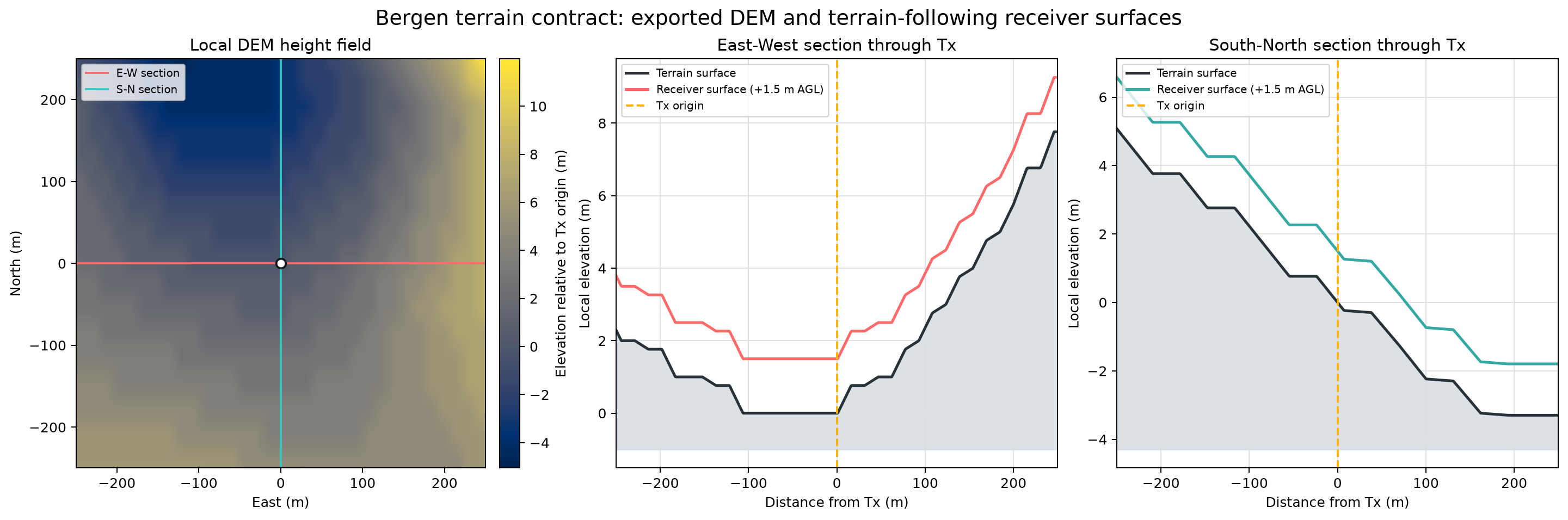
Numerical terrain views from an exported bundle: the local elevation grid, and west-east and south-north profiles through the transmitter with the receiver surface at a constant height above ground.
Effect on simulation#
For Sionna RT, the terrain mesh is part of the ray-traced scene and the measurement surface follows it at the requested receiver height (Sionna RT). The CPU preview remains a planar analytical model and labels terrain as display and export context only. Batch datasets keep the terrain arrays with the shared scene assets even when a case retains no radio products, so a resumed dataset never re-queries a provider for elevation.